US 52
Corridor Study
18 Miles of Opportunity
As the region grows, the connection between Goose Creek and Moncks Corner will be more important than ever.
Let’s plan it right.
What is the US 52 Corridor Study?
The US 52 Corridor Study is a key planning project in the region that seeks to:
- Establish a vision for the US 52 corridor between Moncks Corner and North Charleston.
- Define the relationship between the roadway and adjacent land uses.
- Plan for the corridor’s overall future growth.
It will also offer a range of context-sensitive multimodal solutions – such as high-capacity transit – that maximize existing infrastructure and improve safety and corridor access/mobility.
Finally, the US 52 Corridor Study will support coordinated land uses and corridor preservation across all impacted jurisdictions.
US 52 Corridor Study Draft Documents
Exisiting Conditions Report (Draft)
Download Document > ExistingCondtions (Draft)
Future Scenario Alternatives Report (Draft)
Download Document > Future Scenario Alternatives Report (Draft)
Preferred Future Scenario Report (Draft)
Download Document > Preferred Scenario Report
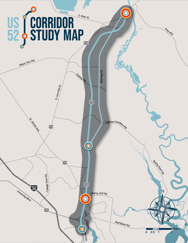
Study map
The US 52 Corridor Study area extends approximately 18 miles between the intersection of US Hwy. 17-Alt. and Rembert C. Dennis Boulevard in Moncks Corner and US 78 (University Boulevard) in North Charleston.
The study area also includes the roughly 12-mile parallel stretch along Old US 52 and Rembert C. Dennis Boulevard/US 52 Bypass in Moncks Corner.
BCDCOG intends to use the study to develop a strong linkage between the corridor’s land use and transportation needs across modes, including roadway, pedestrian and bicycle, and transit networks.
Key Elements
The key elements of the study include:
- Traffic Operations and Safety
- Roadway Geometry and Access Management
- Bicycle and Pedestrian Mobility and Connectivity
- Transit Needs, Including the Preservation of Right-of-Way and Development to Support Future High-Capacity Transit
- Freight Operations, Including Impacts of Adjacent At-Grade Rail Crossings
- Alternate Land Use Scenarios to Achieve a Balance Between Transportation Needs and Impacts
- Environmental Screening of Existing Conditions and Recommended Improvements
- Short-, Mid-, and Long-Term Infrastructure Improvements, Strategies and Policy Recommendations
- Public Outreach and Engagement throughout the planning process
Study framework
Public outreach, virtually and in-person (as appropriate), will take place throughout the study process to inform the community of progress and findings and solicit input in making final recommendations.
Assess Existing Conditions; Develop Short-Term Needs and Recommendations to Improve Capacity and Safety:
Define and Examine Alternative Future Land Use Scenarios:
During the Summer-Fall of 2021 alternative land use scenarios will be developed and tested to determine potential mobility and environmental impacts as a measure against the current land use plan. Alternatives will be used to engage the public and decision makers in establishing a future vision for the corridor.
Phase III
Select a Preferred Land Use Scenario and Recommend Long-Term Improvements:
Prepare the Draft and Final Plans, including Implementation & Funding Strategies:
Phase 1
Assess Existing Conditions; Develop Short-Term Needs and Recommendations to Improve Capacity and Safety:
- Data collection began in Winter 2020 and will continue into early 2021. Analysis of existing conditions and short-term recommendations will be complete by early Spring 2021.
Phase 2
Define and Examine Alternative Future Land Use Scenarios:
- During the Summer-Fall of 2021 alternative land use scenarios will be developed and tested to determine potential mobility and environmental impacts as a measure against the current land use plan. Alternatives will be used to engage the public and decision makers in establishing a future vision for the corridor.
Phase 3
Select a Preferred Land Use Scenario and Recommend Long-Term Improvements:
- During the Winter of 2022, a Preferred Land Use Scenario will be selected for a more detailed examination of impacts and long-term recommendations to improve traffic operations, roadway geometry, bike/ped operations, transit and freight.
Phase 4
Prepare the Draft and Final Plans, including Implementation & Funding Strategies:
- In the Spring of 2022, the project team will complete the draft and final corridor plans. The Final US 52 Corridor Plan will include infrastructure improvement, strategies and policy recommendations, as well as funding and implementation strategies to help guide decision makers.
Study Team
The study team will conduct a comprehensive analysis of existing conditions, an assessment of corridor needs and engage the community in a scenario planning exercise to determine a preferred future land use condition.
The final plan will include a range of context-sensitive short-, and long-term multimodal improvements needed to improve the operation, mobility and safety of the corridor as well as guide decision makers on how the corridor develops.
Partners in the project include:
- Berkeley County Government
- Town of Moncks Corner
- City of Goose Creek
- SCDOT
- Berkeley County Residents
- Businesses and Developers
Get Involved
Have a question that can’t wait?
Contact US 52 Corridor project manager Sarah Cox at sarahc@bcdcog.com or calling (843) 529-2585.

